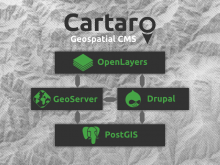
 Cartaro is a Drupal distribution that provides support for spatial data. It seamlessly combines:
Displaying maps within other content
Once you have configured a map in Cartaro you surely want to display it in appropriately. You could use the Frontmap module if your site is
Getting Started
Once Cartaro is installed you will find yourself in a basically empty Drupal instance. Of course if you've chosen to install sample data
How to protect your data
In an GIS environment it is often needed to protect the data provided by the map server, restricting some clients to certain regions or
Installation
This tutorial will guide you through the initial steps to get up and running with Cartaro. Because Cartaro is based on several open source
Print Geospatial Data
A commonly desired functionality is the export of geospatial data as a map. While for screen display a screenshot may be sufficient, higher
Provide Geo Web Services
The tight integration of Cartaro with GeoServer allows you to publish your geospatial data in a multitude of data formats and web services.
Store Geospatial Data
A field type called Geospatial Data is available in Cartaro and can be used to define custom content types. Those fields can hold map
Using Drupal users and roles in GeoServer
The core idea of Cartaro is the closest possible integration of geodata with other content in a single software stack. This aspect also
Using the Docker Container
The Cartaro demo Docker container provides a quick and easy way to get
Visualize Geospatial Data
Custom maps can be configured using the OpenLayers module to visualize geospatial data. This article will describe how to display your
