Active
Project:
Mapping kit
Version:
6.x-1.5
Component:
Miscellaneous
Priority:
Normal
Category:
Support request
Assigned:
Unassigned
Reporter:
Created:
3 Apr 2010 at 15:07 UTC
Updated:
8 Apr 2010 at 08:50 UTC


I use Google Earth to produce kml files (lines, markers and balloon information) so they can be displayed as overlay layers using mapping kit. I'm testing the module and I've encountered several problems in order to show the information properly.
Questions:
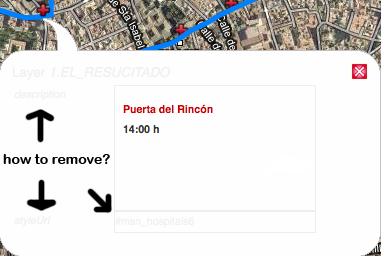
1) Balloon information is not displayed properly compared to Google Earth. (see image attached).
Does that anything to do with how mapping kit 'reads' the kml file? what do I need to modify in the kml code to remove that 'style url' and 'layer 1' field so the balloon just show place and hour?
2)Points are displayed under the main line in mapping kit (while in Google Earth have been drawn on top) and it's difficult to click them. Ideas to correct that?
3) I've realised that when I have more than one layer activated, and click on one point, the balloon doesn't pop up.
4) Does anyone know how to make it work under IE 8? it just works with the compatibility option enabled and not always.
Thanks.
| Comment | File | Size | Author |
|---|---|---|---|
| same_balloon_in_mappingkit.png | 66.52 KB | ylebec | |
| g_earth_balloon.png | 85.79 KB | ylebec |


Comments
Comment #1
jpulles commentedTwo questions in return ;-)
What is your map specification [map .../] and what is your kml file, in order to be able to reproduce your problems.
Comment #2
ylebec commentedMap specification:
[map baselayers="google" center="-4.768117,37.892433" zoom="13" layers="1,2" 1="kml|/sites/default/files/1.line1.kml|1.line1|visibility=false,extractAttributes=true,extractStyles=true" 2="kml|/sites/default/files/2.line2.kml|2.line2|visibility=false,extractAttributes=true,extractStyles=true" width="900" height="600"/]
2 bus lines / stops created in GE, just with their names and hours.