
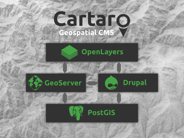
Cartaro is the web mapping platform that brings the power of the best open source geospatial components into Drupal. With Cartaro you are able to set-up and run your own geo-enabled and OGC standards-compliant website with not more than a few clicks. The geospatial components used in Cartaro are PostGIS, GeoServer, GeoWebCache and OpenLayers.
Cartaro is for organisations and individuals that need to run a light-weight spatial data infrastructure (SDI) without the need for extensive configurations and much individual programming. Cartaro is also for all websites that focus on CMS features while also having to handle geospatial data.
Visit cartaro.org for details.
Cartaro on OSGeo-Live DVD
For all who want to try out Cartaro locally but without hazzling with the installation we recommend the OSGeo-Live DVD. Cartaro is included starting from version 6.5. Simply download the ISO and follow the instructions to start the DVD, then run Cartaro Quickstart. Please note that the DVD may lag behind the newest releases of Cartaro. For the newest version always use the download or the demo from this site.
Using Demo Docker container
The Cartaro Demo Docker container provides a quick and easy way to get a local demo installation of Cartaro. The container contains all components needed for Cartaro.
Project information
 Unsupported
Not supported (i.e. abandoned), and no longer being developed. Learn more about dealing with unsupported (abandoned) projects- Obsolete
Use of this project is deprecated.  1 site reports using this distribution
- Created by geops on , updated
 Stable releases for this project are covered by the security advisory policy.
There are currently no supported stable releases.
