

This project is not covered by Drupal’s security advisory policy.
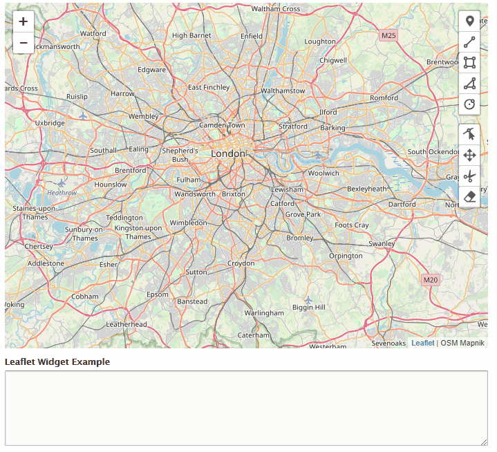
A Geofield widget that provides a Leaflet map and uses the Leaflet widget plugin for adding and removing geometries. Leaflet.widget uses the Leaflet.draw geometry creation tools.
Important : since Leaflet 1.41 and 2.00, this module has been embedded into the Leaflet module, as a submodule (more info). Drupal 7 sites may still use this module, but sites running Drupal 8 and later should switch to Leaflet's submodule.
Features
- Create & manage simple geometries: Point, LineString, Polygon.
- Maintains complex geometries: MultiPoint, MultiLineString, MultiPolygon and GeometryCollection. (These can't be created yet but it won't mess with your existing data.)
- Delete geometries.
- Supports single or multi-value Geofields (cardinality).
- Use base layers defined by Leaflet module.
Installation
Drupal 7
- Install and enable Leaflet Widget and its required modules in the usual way.
Learn more about installing Drupal modules. - Download the Leaflet Widget JavaScript library and place it in
sites/all/libraries.
Ensure you have a path likesites/all/libraries/Leaflet.widget/dist/Leaflet.widget.js
Further documentation How to install Leaflet Widget for Geofield.
Drupal 8
Please use the 2.x branch of the module. You should not use Geofield as a backend for saving the json data. You will lose a lot of important information, because Geofield converts the GeoJON data into WKT and back.
I created a better backend module for saving GeoJSON data based on the standard file field.
To use it, install Leaflet GeoJson File module.
Requirements
Drupal 7
- Libraries (2.x)
- Geofield (1.x or 2.x) please use the same module versions
- GeoPHP 1.x-dev: This module requires the latest dev release as there are issues with parsing GeoJSON in the latest stable release.
- Leaflet Widget requires Leaflet JS to be available. By default the version bundled with the Leaflet.widget library will be used. However if you have Leaflet module installed and Leaflet JS located at
sites/all/libraries/leaflet, that version will be used.
Drupal 8.x-2.0
The 2.x branch is a complete rewrite of the module using Leaflet.geoman.
Important:
Do not use Geofield as a backend for saving the json data. You will lose a lot of important information, because Geofield converts the GeoJON data into WKT and back.
I created a better backend module for saving GeoJSON data based on the standard file field.
To use it, install Leaflet GeoJson File module.
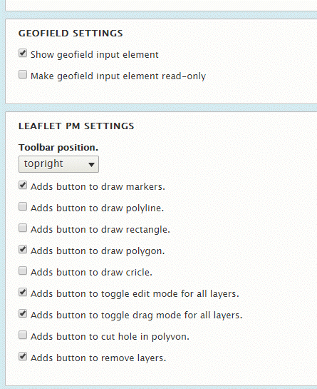
It supports drawing of
- Markers
- Polyline
- Rectangle
- Polygon / Multipolygon
- Circle
It has
- Edit Mode
- Drag Mode
- Cut Mode
- Delete Mode
The GeoJSON Data is saved in the geofield module.

Drupal 8.x-1.0 legacy module
This version is no longer compatible with latest versions of the Leaflet module, and as such it is now deprecated.
- Geofield 1.x
- The Leaflet module.
- Install Wicket in the
/libraries/Wicketfolder.
You can add the following code in your project composer.json file, under the repositories key:
"wicket": {
    "type": "package",
    "package": {
        "name": "arthur-e/Wicket",
        "version": "1.3.4",
        "type": "drupal-library",
        "dist": {
            "url": "https://github.com/arthur-e/Wicket/archive/1.3.4.zip",
            "type": "zip"
        }
    }
}
Then launch this command: composer require arthur-e/Wicket.
Development sponsored by Affinity Bridge.
Project information
 Minimally maintained
Maintainers monitor issues, but fast responses are not guaranteed. Obsolete
Use of this project is deprecated.- Project categories: Site structure
 559 sites report using this module
- Created by tnightingale on , updated
 This project is not covered by the security advisory policy.
Use at your own risk! It may have publicly disclosed vulnerabilities.


